
TLDR
Ruthven Barracks is a free Historic Environment Scotland site 1.5 miles south east of Kingussie. Built in 1721 as a Hanoverian garrison, it was the Jacobites’ final gathering point after Culloden in 1746. The ruins are open day and night, floodlit after dark, with a 50-space car park off the B970.

Insider Tip
Come back after dark. The site is floodlit from dusk to around midnight, the car park is almost always empty, and the silhouette of the ruin against a clear Cairngorms sky is as good as a photograph gets.
Planning your visit? Check current rates at Columba House Hotel, a 25 minute walk from the barracks.
What You Are Looking At

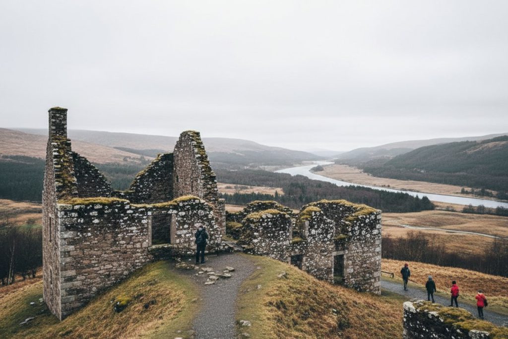
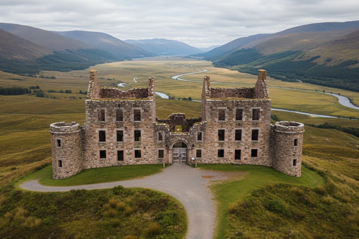
Ruthven Barracks stands on a grassy drumlin above the flood plain of the River Spey, 1.5 miles south east of Kingussie town centre and just across the river from the B970. The mound itself is ancient. It was the site of a medieval castle held by the Comyn family, the Lords of Badenoch, from the 13th century onward, and later occupied by the Wolf of Badenoch in the 14th century. The stone you see today dates from the 18th century Hanoverian barracks that replaced the earlier fortifications.
The surviving ruin consists of two large barrack blocks arranged around a walled courtyard, and a separate stables block on the north side. The outer walls are largely intact. Several internal walls, staircases, and fireplaces survive to first-floor level. There is enough of the structure standing that you can walk the site and work out where the barrack rooms, officers’ quarters, guardhouse, and stables were without needing the interpretation panels, though the panels are worth reading.
The site is managed by Historic Environment Scotland and entry is free, with no ticket, no booking, and no staffed gate. You can turn up at any hour of any day, winter or summer, and wander the ruins without restriction. That is unusual for a site of this historical weight and it is one of the reasons Ruthven is a genuine highlight of any visit to the area.
Why the Barracks Were Built
After the first Jacobite rising of 1715, the Hanoverian government in London decided it needed a permanent military footprint in the Highlands to keep the clans in check. Ruthven was one of four purpose-built infantry barracks commissioned as a result, alongside Bernera at Glenelg, Inversnaid near Loch Lomond, and Kilcumin (later Fort Augustus) at the southern end of Loch Ness. Construction at Ruthven began in 1719 and was completed in 1721.
The design is severely practical. Two parallel three-storey barrack blocks housed around 120 soldiers in two companies of 60, with officers quartered at the ends and the men in rooms holding eight to a room. The whole site was walled, with a single gate and a guardhouse controlling access. The strategic logic of the position is obvious even today: the barracks sit above the main east-west route through the Spey valley and controlled the approaches to the Drumochter Pass and the routes south.
The stables block was added in 1734 under the direction of General Wade, whose road-building programme transformed Highland military logistics. The new stables accommodated cavalry, which extended the garrison’s patrol range significantly. By the mid-1730s Ruthven was a substantial, well-connected outpost on a properly paved military road network.
The 1745 Rising and the Last Stand

When Bonnie Prince Charlie raised his standard at Glenfinnan in August 1745, Ruthven was held by a skeleton force of just 14 soldiers under Sergeant Terence Molloy. At the end of that month a Jacobite detachment of between 200 and 300 men attacked the barracks. Molloy and his tiny garrison held them off with the loss of a single soldier, which is a genuinely remarkable defensive action and one that earned Molloy a battlefield commission as a lieutenant.
In February 1746 the Jacobites came back, this time with about 300 men and artillery. Molloy held out through the initial bombardment but surrendered when it became clear the walls could not stand up to sustained gunfire. The Jacobites occupied the barracks briefly but did not destroy them, and the garrison marched out under terms.
The most significant moment at Ruthven came a few weeks later. On 16 April 1746 the Jacobite army was destroyed at Culloden, but several thousand soldiers escaped the battlefield in reasonable order. Around 1,500 of them regrouped here at Ruthven, still armed, still organised, and still willing to carry on. Many of the surviving senior officers believed the rising could continue if the Prince would give the order. The message they received back from him, relayed from the west coast as he prepared to flee to France, was a single line: each man should seek his own safety. Contemporary accounts describe grown men weeping in the courtyard. Before scattering, the Jacobites blew up the barracks to prevent them being reoccupied by government troops. That explosion is the reason the site stands in ruin today.
What to Expect on the Ground
The car park sits at the base of the mound off the B970 and holds around 50 vehicles. It is free and rarely full. From the car park a short path crosses a low stone bridge and climbs the mound. The climb is steep in short sections but short overall, taking about five minutes at a steady pace. The path is gravel and grass and can be slippery after rain, so proper shoes are sensible even in summer.
At the top you pass through the outer gate into the main courtyard. There are interpretation panels at the entrance and within the site that cover the construction, the garrison life, and the 1745-46 events in reasonable depth. The barrack blocks are open to walk into at ground floor level. Upper floors are inaccessible for safety reasons but you can look up into them from inside. Allow 45 minutes to an hour for a proper visit, longer if you want to sit and take in the views.
There are no toilets and no cafe on site. The nearest facilities are back in Kingussie at the Co-op or one of the pubs on the High Street. Bring water in summer because the mound is exposed with no shade. If you are planning a longer Jacobite-themed day, our local things-to-do guide pairs Ruthven with the Highland Folk Museum for a full half-day of 18th century history.
Views, Photography, and Floodlighting
The view from the top of the mound is one of the best open panoramas in the Spey valley. Looking north, you see Kingussie in the foreground with Creag Bheag rising behind it, and the full line of the Monadhliath on the western horizon. Looking south, the valley narrows toward Newtonmore and the Pass of Drumochter. Looking east, the Cairngorm massif fills the middle distance. On a clear day you can see most of the higher summits in the national park from here.
For photography, the best light is an hour either side of sunrise or sunset. Morning light catches the east-facing walls and puts the Cairngorms in the background. Evening light backlights the ruin from the west and throws long shadows across the mound. The floodlighting after dark gives you a different shot entirely, with the barracks glowing orange against a dark valley. In winter, dusk comes early (around 16:00 in December) and the floodlights come on shortly after, so you can pick up a proper night shot without staying up late.
Drone photography is a grey area at most Historic Environment Scotland sites. Check the current rules on their website before flying. Flash is fine. Tripods are welcome. For the dark-sky photographers, the Cairngorms are a designated dark-sky area and on a clear moonless night you can get strong Milky Way shots with the ruin in silhouette. The VisitScotland dark-sky pages list current conditions.
Getting to Ruthven from Kingussie
The barracks are 1.5 miles south east of Kingussie town centre. By car, follow the High Street east, turn south onto Ruthven Road, cross the River Spey on the B970 bridge, and the car park is on the left after about half a mile. Driving time is about four minutes from the middle of town. Postcode for satnav is PH21 1NR.
On foot, the walk from Kingussie High Street takes around 25 minutes and is mostly flat. The most pleasant route leaves town on Ruthven Road, crosses the footbridge over the Spey, and follows the riverside path to the foot of the mound. In summer the path is a good walk in itself with wild flowers along the verges and wading birds on the flood meadows. In winter parts of it can flood, so check conditions before setting out. By bike the ride takes about eight minutes. Our walking tours guide describes the route in detail with notes on the side paths.
You might also find these useful: Things to Do in Kingussie, Highland Folk Museum Guide, Walking Tours in Kingussie.
“Open ruin on a grass mound, no fee, no staff, just you and the 1721 stonework. Stunning at sunset over Insh Marshes.”
“Beautiful Victorian house, comfortable rooms and a warm welcome. Great location for the Cairngorms and the train station is a short walk.”
See What Columba House Hotel Looks Like

Check current prices at Columba House Hotel
Columba House Hotel in Kingussie is a 25 minute walk or four minute drive from Ruthven Barracks.
Check Available RoomsWe may earn a small commission if you book through this link. It doesn’t cost you anything extra.
See Columba House Hotel for Yourself
Browse All Photos on Booking.com →
This post contains affiliate links. We may earn a commission at no extra cost to you.
Frequently Asked Questions
See Columba House Hotel for Yourself


Browse All Photos on Booking.com →
This post contains affiliate links. We may earn a commission at no extra cost to you.
How much does Ruthven Barracks cost to visit?
Ruthven Barracks is free to enter with no tickets or booking required. It is a Historic Environment Scotland property maintained as an open ruin. Donations to HES are welcome.
When is Ruthven Barracks open?
The site is always open, 24 hours a day, year-round. There are no staff, no gates and no opening hours. Dawn and dusk give the best light for photography.
What is the history of Ruthven Barracks?
Built by the Hanoverian government in 1721 after the 1715 Jacobite rising, the barracks garrisoned English troops until 1746. Jacobites burned it after Culloden so it could not be reused. Earlier mediaeval castles occupied the same mound from the 1200s.
Where is Ruthven Barracks?
Ruthven Barracks sits 1.5 miles southeast of Kingussie on the B970, across the River Spey. A small free car park is at the base of the mound. Allow 15 minutes to walk up.
Can I walk from Kingussie to Ruthven?
Yes, the walk is 1.5 miles each way on pavement and quiet road, 45 minutes each way. Paths can be muddy after rain. The steep final approach up the mound takes a few minutes.
How long do I need at the site?
Allow 45 minutes to an hour including the climb, exploring the ruin and taking photos. It is a small site with no visitor facilities, so combine with a walk or picnic. Evening golden-hour light is particularly good.
Is it good for kids?
Yes, the open ruin with stairs, passageways and views of Insh Marshes keeps kids engaged. The site is unfenced at the mound edges, so supervise closely. No facilities so bring water and snacks.
Is Ruthven Barracks accessible?
The path up the mound is steep and partly on grass, not suitable for wheelchairs or buggies. Views of the ruin from the car park give a decent impression without the climb. There are no toilets on site.