

TLDR
A practical guide to Walking Tours for visitors to Kingussie. Covers what to expect, how to get there, and practical tips from the ground.

Insider Tip
Ask at Columba House Hotel for up-to-date local recommendations. The staff know what’s worth your time right now.
Planning your stay? Check current rates at Columba House Hotel, a convenient base for exploring Kingussie.
What to Expect

Walking Tours in Kingussie is one of the highlights of the Kingussie area. Whether you’re spending a few hours or a full day, it’s worth including in your plans.
How to Get There
From Columba House Hotel in Kingussie, the easiest options are taxi, ride-hailing app, or public transport. Check locally for current schedules and prices.
“Short sharp climb with views across the Spey valley to the Cairngorm plateau. Took us just under two hours up and down at steady pace.”
“Stayed three nights, fantastic food and a very comfortable room. Would come back to Kingussie just to stay here again.”
See What Columba House Hotel Looks Like

Check current prices at Columba House Hotel
Columba House Hotel in Kingussie, a solid base for exploring everything on this list.
Check Available RoomsWe may earn a small commission if you book through this link. It doesn’t cost you anything extra.


Practical Tips

Visit early in the day to avoid crowds. Bring water, comfortable shoes, and sun protection. Check opening hours before you go, because they can change seasonally. Our month-by-month guide covers what changes when.
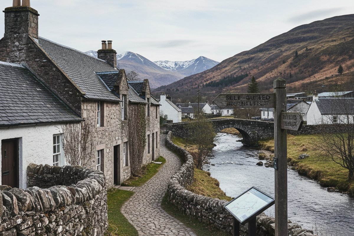
The Gynack Burn Loop: Three Miles From the High Street
The Gynack is the small river that runs through the middle of Kingussie, and the loop along its banks is the easiest introduction to walking here. Start at the top of the High Street where the road narrows by the war memorial, turn up West Terrace, and follow the signs for Gynack Wood. The path climbs gently alongside the burn for about a mile, passing the small falls where the water drops over a rocky shelf, and reaches a footbridge above the old mill dam. Cross here, drop down the western side, and you will loop back into town past the edge of the golf course. Allow 75-90 minutes at a relaxed pace with time to stand and watch the water, which on still days runs so clear you can see trout holding in the deeper pools.
The path is mostly packed earth and gravel with a few rooty bits near the falls, so trainers are fine in dry weather, but it gets slippy after rain and proper walking shoes are kinder in autumn when the leaves come down. Dogs are welcome off the lead on most of the route, though the golf course section asks for them on a short lead because of the fairways. In early summer (mid-May to June) the wild flowers along the burn are excellent: stitchwort, wood anemone, and occasional patches of bluebells in the shadier dells. Late September brings bracken turning copper and the rowan trees fruiting scarlet, which is when this walk is genuinely at its best.
One practical tip locals know. If you start the walk from the Columba House end of town, pop into the bakery on the High Street first and pick up a couple of rolls. There is a perfect bench about halfway up the burn with a view back over the rooftops to Creag Bheag, and a cold roll eaten there with the water sound behind you is hard to beat. If you have time for more after, the same network of paths links onto the longer routes up Creag Bheag or out toward the Kingussie golf course clubhouse, so you can extend it into a half-day without retracing steps. For broader planning, our things to do in Kingussie local guide puts the walks in context with the other highlights, and the Kingussie Golf Club guide covers the clubhouse end.
Creag Bheag Summit: A Two-Hour Hill With Big Views
Creag Bheag (pronounced “Craig Vek”, meaning Little Crag in Gaelic) is the hill directly behind Kingussie and it is the single best two hours you can spend on foot in this town. The summit sits at 487 metres, which is not huge by Scottish standards, but because the town sits at 270 metres you only have to climb around 220 metres of actual ascent. The 360-degree view at the top is extraordinary. You can see the whole Cairngorm plateau to the east, the Monadhliath hills rolling west, the Spey valley below with its oxbows and marshes, and on a genuinely clear winter day the Nevis range shows up as a hazy white line on the southwest horizon.
Start from the same top-of-High-Street point as the Gynack walk, but take the signed path that branches right at Pitmain Lodge. The route climbs through birch and Scots pine, emerges onto heather moorland after about 45 minutes, and finishes on a short rocky ridge to the small cairn at the top. Most people do the round trip in about two hours including 15-20 minutes on the summit for a flask and a sit. Descend the same way or drop down the western flank on the less obvious path toward Loch Gynack (add 30 minutes). The path is well-trodden but boggy in places after rain, so walking boots with ankle support earn their keep on the descent.
Weather matters more on Creag Bheag than on the burn loop because once you are out of the trees there is no shelter. Check the mountain forecast the night before (MWIS covers the eastern Highlands) and if it says cloud base below 500 metres or gusts over 40mph, save it for another day and do the lower walks instead. The whole Cairngorms region deserves a bit of respect. The national park’s own safety advice on the Cairngorms National Park site is worth reading before your first bigger walk, and VisitScotland has further Highland safety notes. Midges are rare on the summit itself (too much wind) but can be brutal in the lower birch woods May to September, so pack repellent. Our is Kingussie safe guide covers weather, midges and driving in more detail.
Ruthven Barracks and the River Spey Path
The Ruthven Barracks loop is the neatest two-mile walk in the area and it works in almost any weather because it stays low. From the centre of Kingussie, walk down Ruthven Road past the service station, cross the Spey on the old stone bridge, and follow the signs for Ruthven Barracks. The path skirts the edge of the Insh Marshes RSPB reserve, with boardwalks in the wetter sections and open views across one of the largest floodplain wetlands in Britain. The barracks themselves appear on a grassy knoll to your right. It’s a Hanoverian fort from 1719, torched by the Jacobites after Culloden in 1746, and now a wind-scoured ruin with the roofless walls still standing impressively proud. Our Ruthven Barracks guide has the fuller history, and Historic Environment Scotland lists any seasonal notes.
Entry is free and open all hours. There is no visitor centre, no ticket booth, and no café, which is exactly why the place keeps its atmosphere. Climb the grass mound to the barracks (five minutes), walk around the inside of the walls, and stand on the southern rampart looking back across the river to the Cairngorm plateau. On still evenings in summer the light on the hills here is as good as anything you will see in Scotland. Allow 30-45 minutes on site if you want to read the information boards, which cover the Jacobite period well, and then either retrace your steps or complete the loop by continuing east along the Spey path and crossing back by the B970 bridge.
If you fancy extending the day, the combined Ruthven Barracks and Insh Marshes outing works well as a half-day loop. Start in Kingussie, walk out to the barracks (30 minutes), spend 45 minutes on site and in the grass below looking at the view, then drop down to the RSPB Insh Marshes entrance and walk the full boardwalk (another 45 minutes with stops at the bird hides), and finally loop back along the B970 riverside path to Kingussie. Total time around three hours including stops, total distance about five miles, and not a single significant climb. Take binoculars if you have them because the marshes are a serious bird reserve rather than a tourist flourish, with over 180 species recorded and genuine rarities turning up on migration. Sensible footwear, windproof jacket, and a packed lunch transform this into one of the best relaxed days in Speyside.
The River Spey path itself is a quiet pleasure and extends much further if you want it. Walking east from the Ruthven bridge you can reach the Insh Marshes main RSPB boardwalk in about 40 minutes, and continuing on you can pick up parts of the Speyside Way long-distance footpath. Birdlife is excellent year-round: lapwings and redshank in spring, whooper swans and goldeneye in winter, and if you are very lucky an osprey fishing in summer (they nest at Loch Garten a few miles north). The whole loop back to Columba House via Ruthven Barracks and the river path is a comfortable two-hour outing with a genuine sense of history built in, and you can do it in near silence on a weekday morning outside of school holidays.
“Richard Jones, 3/5, 3 months ago”
Guest, verified guest
You might also find these useful: Best Day Trips from Kingussie, Best Restaurants in Kingussie: Where to Eat, Best Time to Visit Kingussie: Month by Month Guide.
See Columba House Hotel for Yourself
Browse All Photos on Booking.com →
This post contains affiliate links. We may earn a commission at no extra cost to you.
Frequently Asked Questions
See Columba House Hotel for Yourself


Browse All Photos on Booking.com →
This post contains affiliate links. We may earn a commission at no extra cost to you.
What is the best short walk in Kingussie?
The Gynack Burn loop is 3 miles on good paths with waterfalls and woodland, taking 1.5 hours at easy pace. It starts at the Clock Tower and returns via the golf course. Buggy-friendly on the first half.
How hard is Creag Bheag?
Creag Bheag is a small hill at 487 metres, 2 hours up and down from town on a waymarked path. The climb is steady with one rocky section near the top. Suitable for reasonably fit walkers in trainers or light boots.
Can I walk from Kingussie to Ruthven Barracks?
Yes, it is 1.5 miles each way along a mix of pavement and riverside path. Allow 45 minutes each way, or 2 hours round trip with time at the ruin. The route crosses the Spey on a road bridge.
Is Insh Marshes worth visiting?
Yes, the RSPB Insh Marshes reserve has a short boardwalk and two hides, open year-round and free. Spring brings lapwings and redshanks, winter whooper swans. The reserve is 1 mile south of Kingussie on the B970.
What should I pack for local walks?
Waterproof jacket, warm layer, hat, water, snacks and map or app (OS Maps works well offline). Midge repellent May to September. Phone signal is patchy in glens so tell someone your route.
Are there accessible walks for wheelchairs or buggies?
The lower Gynack path, Insh Marshes boardwalk and Ruthven Barracks approach all have hard surfaces suitable for buggies and most wheelchairs. Loch an Eilean at Rothiemurchus (20 minutes’ drive) has a fully accessible 3.5 mile loop. Hill paths are not accessible.
Can I do a longer hillwalk from Kingussie?
Yes, Carn an Fhreiceadain at 878 metres is a Corbett behind town, 5-6 hours return on estate tracks. The Monadhliath hills start directly above Creag Bheag. Serious hillwalkers use Kingussie as a base for Feshie and Gaick too.
Are dogs welcome on walks?
Yes, under close control and on leads during lambing (April-May) and bird nesting (March-July). Creag Bheag, Gynack and Ruthven all welcome dogs. Insh Marshes asks for dogs on leads year-round because of ground-nesting birds.